Overview of Bong County
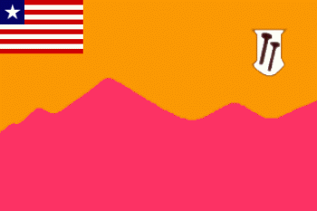
Flag of Bong County
Photo Credit: MIA Related Documents
|
Bong is a county in the north-central portion of the West African nation of Liberia. One of 15 counties that comprise the first-level of administrative division in the nation, it has twelve districts. Gbarnga serves as the capital with the area of the county measuring 8,772 square kilometres (3,387 sq mi).[1] As of the 2008 Census, it had a population of 328,919, making it the third most populous county in Liberia.
Named after Mount Bong in the southern portion of the county, it is bordered by Lofa and Gbarpolu counties to the north, Margibi and Montserrado counties to the west, Grand Bassa County to the south, and Nimba County to the east. The northeast part of Bong borders the nation of Guinea. Created in 1964, the County Superintendent is Selina Polson Mappy. Bong County’s flag is purple, signifying the dawn, and orange, signifying the County’s newness.[citation needed] The two geological instruments in the white field portion of the flag symbolize Bong County’s mining industry.
Bong County was created in 1964, along with Nimba, Lofa and Grand Gedeh, when the administrative sub-divisions of Liberia were increased to a total of thirteen. The capital is Gbarnga, named after an old farm in the location.
Geography
Bong County is situated in the central part of Liberia, on the main paved road that runs from Monrovia to Sanniquellie in Nimba County.
Districts
Bong County has twelve districts (2008 population):
- Boinsen District (8,352)
- Fuamah District (27,784)
- Jorquelleh District (78,803)
- Kokoyah District (3,707)
- Kpaai District (25,127)
- Panta District (16,326)
- Salala District (41,982)
- Sanayea District (30,932)
- Suakoko District (28,277)
- Tukpahblee (11,767)
- Yeallequellah (36,919)
- Zota District (18,943)
Demographics
The population of Bong from the 1984 Census was 255,813 for the 8,772 square kilometres (3,387 sq mi) county.[1] In July 2005, the population was estimated to be around 804,000.[3] In 2008, the Census placed the figure at 328,919, ranking it third in Liberia after Montserrado and Nimba.[1] The main ethnic groups include the Kpelle, Mandingo and Mano.